
30/07/2026
-
Products
-
-
Explore
- About Us
- Where to Buy
- Support
Products
Explore
Real-world RTK GNSS accuracy depends on satellite geometry, signal obstructions, baseline distance, and correction latency. To evaluate a result, confirm that the receiver maintains a stable fixed status and returns repeatable coordinates across multiple passes. A float status or noticeable drift is not reliable enough for close boundary work. Prioritize a setup that produces consistent fixed solutions in the most challenging parts of your site.
A robot lawn mower, survey app, or boundary-mapping tool may look precise in clear conditions and wander near a hedge on another day. That difference can frustrate homeowners who expect coordinates to behave like measurements from a tape, especially around lawn edges, beds, paths, and trees. RTK GNSS accuracy is not one published number that applies everywhere. Start with the practical accuracy range, then check if your site can support it.
RTK GNSS can stay within a narrow inch range when the receiver maintains a fixed solution, corrections remain stable, and the location has a clear view of the sky. Results can vary across the same property, so evaluate accuracy against the tolerance of the job rather than an ideal headline number.
For lawn and yard work, that difference matters. A mower boundary along an open driveway can usually absorb more variation than a line beside a flower bed, pond edge, or narrow path.
Treat RTK results as dependable only when three checks agree: fixed status, stable correction data, and repeatable measurements at the exact location. Stop adjusting boundaries or saving points if the receiver drops to float, reports weak corrections, or shows visible drift across repeated passes.
Site conditions reveal the practical meaning of RTK GNSS: satellites, a reference source, a correction link, and a rover must all work together, so check the location first before blaming the receiver or app.
Strong RTK performance requires enough satellites distributed across the sky. An open view provides better geometry for separating position, timing, and atmospheric errors. Trees, rooflines, fences, and slopes may limit that view or block signals. In a mid-sized yard, weak areas are often predictable: under dense tree cover, beside the house, near sheds, and along narrow side yards. Treat those areas as conditional instead of expecting the same inch-level performance everywhere.
RTK depends on the correction relationship between a base or network reference and the rover. Shorter baselines generally support better results because the base and rover share more of the same atmospheric and satellite errors. Longer baselines can still work, but the margin narrows when signal conditions are already difficult. For residential boundary work, place a local reference point where it has open sky, stable footing, and few obstructions.
Corrections must arrive consistently and with low enough latency to match the rover’s current observations. Delayed, interrupted, or poor-quality data can turn an apparently stable position into a lagging estimate. Watch for app warnings, dropped connections, or status changes while moving. If correction quality changes near a back fence or behind a garage, pause before saving boundary points. A stable correction stream is just as important as the receiver’s stated capability.
Fixed RTK status means the receiver has resolved carrier-phase ambiguities well enough for high-precision positioning. Float status means it has not reached that confidence level, even if the map marker looks steady. The two states are not interchangeable. Fixed status is required for close boundary work. If the system falls back to float near an obstruction, stop and reassess the conditions instead of repeatedly moving the line.
Antenna height, level mounting, and open surroundings directly affect repeatability. Multipath occurs when signals reflect off walls, metal edging, vehicles, water, or hard landscaping before reaching the antenna. The receiver may still show a position even though the signal path is distorted. Keep the antenna away from reflective surfaces when possible, remove temporary obstructions during mapping, and repeat measurements with the same setup. Small placement changes can introduce more error than the adjustment you intended.
Evaluate reliability through repeatability, consistent status, and the tolerance of the job. Measure first, make the decision second, and adjust last. One clean-looking point is weaker evidence than several passes that land in the same narrow range while the receiver stays fixed and corrections remain stable.
For yard boundary work, map the same edge more than once under similar conditions. Reliable results should follow the same physical feature without visible wandering across beds, paving, or turf edges. If repeated passes separate enough to change the practical decision, the result is not reliable enough for that boundary.
If the device does not provide a precise threshold, use visible checks: fixed status remains active, no correction warnings appear, the position does not jump while stopped, and the mapped line matches known straight edges or corners. Stop adjusting when each change is smaller than the repeatability error already present. If every change creates a different problem, measurement quality—not boundary placement—is the limit.
Choose an RTK GNSS setup for the most demanding part of your yard, not the easiest one. Open turf, wide mowing areas, and simple perimeter mapping place fewer demands on the system than shaded edges, narrow passages, steep boundaries, and planting beds close to the mowing line.
Prioritize three things: stable fixed RTK performance in your yard, clear status reporting, and correction coverage everywhere the equipment will operate. If a system hides fix quality or correction problems, troubleshooting becomes harder because you cannot separate poor geometry from an adjustment issue.
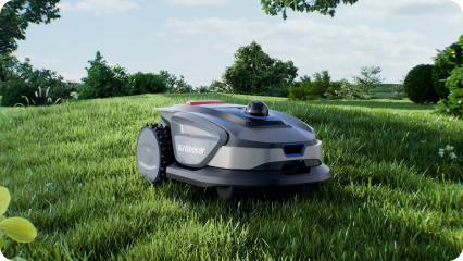
For robotic mowing, the Sunseeker X7 is worth considering if you want wire-free boundary guidance based on advanced positioning. Evaluate it as you would any other option: map the most difficult edge, repeat the route, and confirm that the result stays within the tolerance your yard requires. If the mower cannot hold that edge consistently, other features do not resolve the accuracy issue.
RTK GNSS can be accurate enough for yard boundaries when the receiver stays fixed, corrections remain stable, and repeated passes agree within the tolerance of the edge. If those checks fail, pause and review the site, timing, or setup before trusting the mapped line. Test the hardest boundary first and keep only measurements that repeat consistently under normal operating conditions.
A fixed RTK solution can provide positioning within a narrow inch range after the receiver resolves carrier-phase ambiguities. Fixed status is the key requirement for close boundary mapping. If the receiver drops to float, accuracy decreases, so wait for a stable fixed solution before saving the boundary.
A stationary base or reference network estimates positioning errors and sends corrections to the moving rover. A shorter baseline often helps the base and rover share similar atmospheric and satellite error patterns. The correction data must also arrive consistently and with low latency for the rover to maintain a fixed solution.
Start with the most difficult boundary, such as a shaded edge or narrow passage. Repeat the route under similar conditions and compare how closely the mapped lines follow the same physical feature. If the receiver drops to float or the lines wander beyond the yard’s tolerance, the setup is not reliable enough for that area.